Bridging Challenges and Opportunities with Drone Mapping
Imagine standing on a vast, untamed stretch of land that needs to be mapped. The terrain is rugged, inaccessible, or simply too expansive to be surveyed effectively using traditional methods. The clock is ticking, budgets are tight, and the margin for error is razor-thin. For many professionals in fields like construction, agriculture, or environmental science, this is a daily challenge. This is where aerial mapping with drones enters the picture, transforming what once seemed like an insurmountable task into a highly efficient process.
The growing demand for precision and speed in modern surveying has positioned drone surveying in Australia as a game-changer. With advanced technology, aerial survey mapping drones are revolutionising the way we gather, analyse, and visualise data. Whether you’re involved in infrastructure planning, environmental conservation, or property development, the insights offered by drone survey mapping solutions can save you time, reduce costs, and significantly improve outcomes.
Curious about how this innovative technology works and why it’s reshaping industries? Read on to uncover the step-by-step process, real-world success stories, and the unique ways Australian aerial mapping is setting global benchmarks.
Ready to revolutionise your project with drone mapping? Contact AUAV today for a consultation!

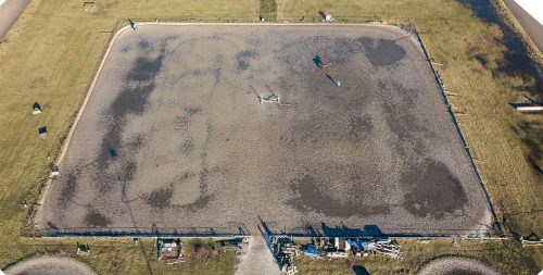
Step-by-Step Process of Conducting Aerial Mapping
Understanding the workflow of aerial mapping using drones helps demystify the process and highlights the expertise required for high-quality results. Here is a step-by-step breakdown:
- Project Planning and Goal Setting
- Define the purpose of the aerial survey. Are you assessing land for construction, measuring agricultural yields, or monitoring environmental changes?
- Establish key parameters like area size, resolution needs, and deliverables.
- Secure permits and comply with local aviation regulations, particularly those outlined by Australia’s Civil Aviation Safety Authority (CASA).
- Equipment Selection and Calibration
- Choose the right drone and sensors for the task. Common options include LiDAR sensors for terrain mapping and multispectral cameras for agricultural surveys.
- Perform pre-flight checks to ensure the drone is in optimal condition and properly calibrated for accurate data collection.
- Flight Planning
- Use specialised software to design a flight path that ensures comprehensive coverage of the survey area.
- Consider factors such as altitude, overlap, and weather conditions.
- Data Collection
- Conduct the drone flight according to the pre-set path. Drones capture high-resolution imagery or 3D data, depending on the project’s requirements.
- Monitor the flight in real time to address any issues immediately.
- Data Processing
- Upload collected data into software for processing. This typically involves stitching images together to create orthomosaic maps or 3D models.
- Analyse the data for specific metrics like elevation, vegetation health, or structural dimensions.
- Delivering Results
- Generate detailed reports, maps, or 3D visualisations as per the client’s needs.
- Offer interactive tools or platforms for stakeholders to explore and utilise the data effectively.
Discover how Australian aerial mapping services can deliver accurate results for your next project.
Key Deliverables from a Professional Aerial Mapping Service
When you invest in professional drone survey mapping solutions, you’re not just paying for data collection—you’re accessing actionable insights. Here are the most common deliverables:
- Orthomosaic Maps: High-resolution, georeferenced maps ideal for urban planning or environmental assessments.
- 3D Models: Digital elevation models (DEM) and 3D point clouds that aid in construction planning and volumetric analysis.
- Vegetation and Crop Health Reports: Multispectral imaging for agriculture, revealing plant health and irrigation issues.
- Volumetric Calculations: Accurate measurements of stockpiles, excavations, or landfills.
- Change Detection Reports: Comparative analysis to track land-use changes over time.
Challenges in Aerial Mapping and How Drones Overcome Them
Traditional mapping techniques often face significant challenges that limit their efficiency and effectiveness. Inaccessibility is a major concern, as steep terrains, dense forests, and remote locations make manual surveys difficult and sometimes unsafe. These methods are also time-consuming, with ground-based surveys often taking weeks to complete, delaying important decisions. Additionally, the labour-intensive nature of traditional surveys, combined with the need for expensive equipment, leads to high costs. On top of that, human errors during manual processes can result in data inconsistencies, affecting the reliability of the results.
Drones for surveying provide practical solutions to these challenges. Their ability to access hard-to-reach areas makes them ideal for mapping locations that are otherwise unsafe or impractical for human teams. What once took weeks can now be achieved within hours, thanks to the speed and efficiency of drones. This rapid data collection also reduces manpower needs, making the process far more cost-effective. Moreover, drones are equipped with advanced sensors and GPS systems, ensuring precise and consistent data collection.
By overcoming these traditional obstacles, drones are transforming mapping and surveying, enabling industries to gather accurate information quickly and at a reduced cost.

Tips for Ensuring High-Quality Aerial Survey Results
Achieving reliable results requires careful attention to detail. Here are some best practices:
- Understand the Terrain: Study the survey area beforehand to anticipate challenges like wind patterns or obstacles.
- Choose the Right Tools: Match the drone and sensor capabilities to the project’s specific needs.
- Maintain Proper Overlap: Ensure adequate image overlap during flights for seamless data stitching.
- Time Your Flights: Conduct surveys during optimal lighting conditions to reduce shadows and glare.
- Regularly Calibrate Equipment: Keep drones and sensors in top condition to avoid errors.
- Partner with Experts: Work with a trusted drone survey company that understands local regulations and industry requirements.
How Australian Aerial Mapping Services Are Leading the Global Market
Australia is at the forefront of drone mapping innovation, thanks to:
- Favourable Regulations: CASA’s structured guidelines make it easier for companies to integrate drones into commercial operations.
- Diverse Landscapes: From arid deserts to bustling urban centres, Australia’s varied geography drives innovation in mapping solutions.
- Advanced Research: Local universities and tech firms are continually pushing the boundaries of drone technology.
Innovations in Australian Aerial Mapping Services
Australian companies are embracing cutting-edge advancements such as:
- LiDAR Technology: Offering unparalleled detail for topographical surveys.
- AI and Machine Learning: Automating data analysis to deliver faster and more accurate insights.
- Beyond Visual Line of Sight (BVLOS): Expanding the range of drone operations, enabling large-scale mapping projects.
- Hybrid Drones: Combining fixed-wing and multi-rotor designs for efficiency and versatility.
How Local Companies Are Shaping the Global Drone Mapping Industry
Australian companies are not just meeting local demand; they’re setting global trends by:
- Offering end-to-end drone mapping solutions to international clients.
- Participating in global collaborations to develop new technologies.
- Establishing training programs to upskill drone operators worldwide.
Partner with Experts in Aerial Mapping
The use of aerial surveys with drones is reshaping how industries approach data collection, bringing precision and efficiency to projects of all scales. From construction and infrastructure planning to environmental monitoring, drone-based mapping delivers highly accurate insights that save time and resources. AUAV is a leader in this field, offering cutting-edge drone technology and expert solutions to meet the diverse needs of clients across Australia.
Our team works closely with clients to tailor aerial mapping solutions to specific project requirements, using advanced equipment to capture high-resolution imagery and data. With our expertise, industries gain the clarity and accuracy they need to progress and succeed in a competitive landscape.
Learn more about AUAV’s cutting-edge drone survey solutions. Request a free quote here!


