What is a Drone? What is UAV Technology?
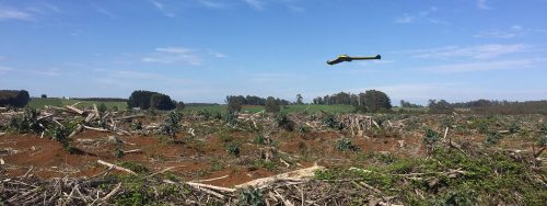
Drones, also referred to as “Unmanned Aerial Vehicles” (UAVs), are essentially flying robots that can be remotely controlled using software-controlled flight plans in their embedded systems that work in conjunction with sensors and a global positioning system (GPS).
These robot-like vehicles can carry out tasks ranging from mundane to ultra-dangerous and everything in between. They were initially developed for the military and aerospace industries. But now, they have found their way into the mainstream because of the enhanced levels of safety and efficiency they bring to the table.
Types of Drones
- Multi-rotor
- Fixed-wing
- Single-rotor helicopter
- Fixed-wing hybrid VTOL
We have covered the different types of drones in another blog.
What are the Commercial Uses of a Drone?
Drones are used in almost every sector, expanding their usage across various industries. Here is a quick list of what drones are being used for:
Inspections
- Asset Inspection
Drones are capable of close visual inspections of different assets to quickly spot defects such as cracks, structural issues, leaks, damaged tiles, corrosion, etc. - Roof Inspection
This aerial system performs roof inspections and can go places that humans cannot reach. This reduces or eliminates the risk of injury also saves an incredible amount of time. - Power Station, Transmission and Distribution
UAV technology ensures that transmission lines operate normally, allowing operators to analyse a malfunction from the ground before climbing to fix it. Thus, drones increase efficiency and speed of maintenance. - Telco and Radio Towers Inspection
Drone tower inspection helps capture high-resolution imagery to assess the conditions, enabling businesses to analyse reports and make informed decisions. - Oil & Gas Industries
Drones can inspect oil and gas, resulting in more consistent and faster data collection, thus enhancing the longevity of the assets. This reduces downtime and hazards.
Get enterprise-grade aerial intelligence to inspect your assets. Use AUAV aerial inspection and data services.
Monitoring and Management
- Waste Management
Drones used in waste management can simplify many operations, including garbage collection and landfill monitoring. They can also be used in cleaning garbage – identifying and picking garbage for disposal. - Road Safety
Road safety-based application of UAVs includes risk assessment, detailed accident investigation, and overall surveillance of road network. - Traffic Monitoring and Management
Drones are used for traffic surveillance and monitoring. Online and offline traffic parameters are extracted from the drone video data to improve traffic monitoring and management mechanisms. - Highway Infrastructure Management
UAV technology is used to monitor and manage highway infrastructure and, more importantly, bridge inspection and pavement distress recognition. - Agriculture
Agricultural drones provide farmers, researchers, and service providers a fast and efficient way to scout their crops, track plant growth, spot stress, create treatment plans, and more. - Environmental
Drone technology offers a faster, safer and cost-effective method for mapping and monitoring large areas for environmental investigation, protection and management, where human and vehicle access is dangerous and difficult. - Natural Hazards and Disaster Relief
Drones can incite prompt on-ground action during natural disasters, incredibly faster than manual detection, analysis, and action. This significantly reduces overall disaster response time, thus reducing the extent of a potential disaster. Equipped with sensors like infrared, drones can precisely locate and visually identify humans in distress and help deliver medical samples, supplies, and medicine and rescue them. - Forestry
Drones are used to map natural and man-made forests, providing accurate and timely data for analysing tree health, tree counting, biomass estimation, canopy measurement and planting management. - Port and Marine
Drones are used in ports and marine for surveying hard to reach places and assessing a vessel’s condition. Aerial surveying removes the logistics and time investments and delivers on-demand insights in port monitoring, traffic control, operational oversight and environmental health and safety. - Waterways Coastal
Drones are becoming more mainstream on waterways and are used in various applications, including monitoring vessel traffic, water quality and levels, weather and fish populations. Equipped with sensors, the drones can inspect ships and cargo containers for harmful substances and also can pick up trash in the water.
Surveying and Aerial Mapping
- Aerial LiDAR
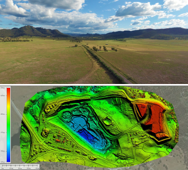
Drone technology coupled with LiDAR technology can map surveys to generate 3D models with centimetre-level accuracy. A drone can perform aerial mapping and surveying by flying 100m to 200m above the survey area. - 3D Modelling
Survey drones can create high-resolution orthomosaics and detailed 3D models of areas that require high-accuracy cadastral maps to be generated quickly and easily, even in difficult to access environments. - Metro Map
The drones are used to carry out detailed surveys, measure, demarcate, and geo-reference the area while capturing aerial photographs and videos and preparing metro maps. - Mining
Industrial-grade drones are used at mining sites for surveying, asset inspection, terrain mapping, stockpile estimation, security and surveillance. They provide aerial perspectives of the mining sites at a fraction of a cost and improve operational efficiency. - Landfill Sites
Drone mapping is used at landfill sites to help identify potential concerns early, ensuring the safety of the crew. Moreover, it detects environmental hazards, like leaching chemicals and gases, before they become dangerous and costly.
AUAV is uniquely qualified to deliver on critical aerial mapping and surveying projects — on time and in budget.
Construction
- Land Development
Aerial images taken by drones simplify and accelerate the process of topographic surveys for land planning, development and management. Construction drones help in site scouting, allotment planning and design, and also the construction of buildings, roads, and utilities. - Civil Engineering Projects
Drones produce high-quality information, images, and models in civil engineering at lower costs. Drone-mounted cameras capture images from multiple angles, which are then processed to create digital models. - Real Estate
Real estate use drones to take awesome aerial images and videos to provide a unique perspective while featuring a property. Drone photography offers prospective buyers a 360-degree view of the property and its adjoining points of interest.
Photography and Videography
- Cinematography
Drones improve efficiency and productivity in the field of cinematography by capturing new angles, which till now were impossible to achieve. - Wedding and Events
Drone photography is used to get aerial footage of the wedding or event. Drone shots capture illustrative and dynamic photos and videos that can efficiently display a wedding or event’s scope and scenic context. - Advertising
Advertising companies use drones to complement their marketing campaigns. The images and videos captured by UAVs are used to create higher quality and more engaging content to keep the customer engaged. - Promotional Photography
Powerful aerial photos and video are exceptional marketing tools. Beautiful and detailed imagery captured by drones help in attracting the attention of customers and thus increase sales.
Key Benefits of Using Drones
- Increase work efficiency and productivity.
- Decrease workload and production costs.
- Improve accuracy and precision.
- Refine service and customer relations.
Get Started with AUAV
Drone technology is no longer limited to just military uses; it has found a vast number of uses and applications in different sectors as we have discussed above. Different businesses are now investing in drones to increase efficiency, decrease costs, and improve their workers’ health and safety.
Drones present immense opportunities for businesses, making it possible to collect data and access information in a variety of ways while saving time and minimising costs. As technology advances, drones will evolve to become more robust, capable of accommodating heavier loads and longer flight times.
Therefore, it’s important for organisations to analyse the scope of drone technology in their line of business to enjoy its benefits. But to fully realise the benefits of this technology, you need experts who understand how to apply it. That’s where AUAV comes in. Contact us now and learn how we can help you meet your goals.
